| View Question |
|
|
| Subject:
new orleans
Category: Miscellaneous Asked by: jdubkid-ga List Price: $20.00 |
Posted:
11 Feb 2006 17:03 PST
Expires: 13 Mar 2006 17:03 PST Question ID: 444656 |
the french quarter is made up of a series of sqaures. i need to know what the length of the square that is made up of these four streets. Bourben Street, Saint Peter Street, Royal Street and Toulouse Street (from building to buildig or sidewalk to sidewalk). Also the width of the saint peter street. | |
| |
|
|
| There is no answer at this time. |
|
| Subject:
Re: new orleans
From: myoarin-ga on 14 Feb 2006 07:04 PST |
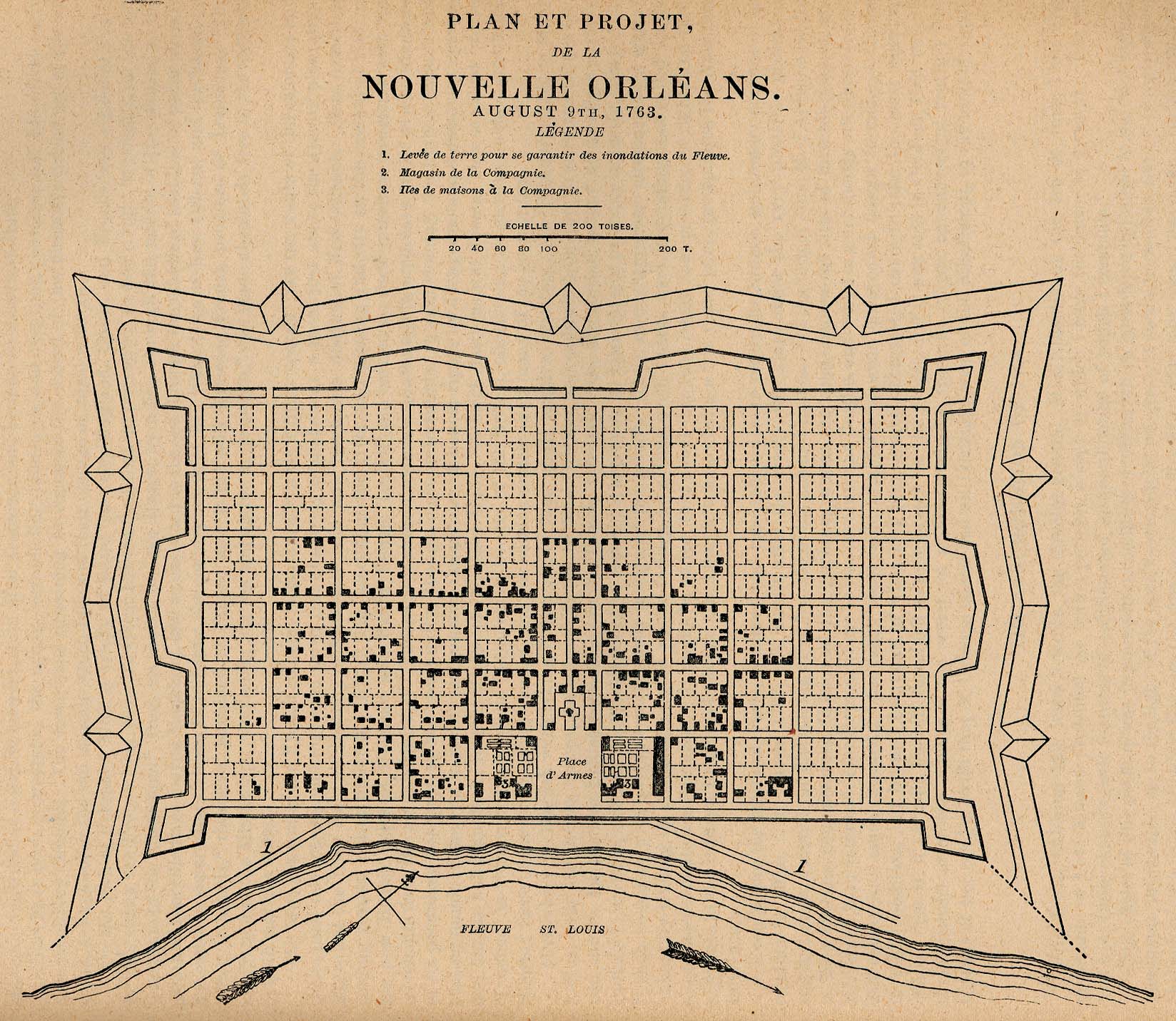
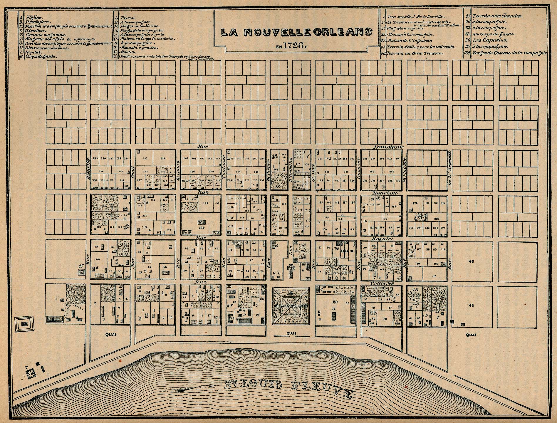
How about this: http://www.lib.utexas.edu/maps/historical/new_orleans_1763.jpg Click to enlarge and you will see that the scale is in "toises" (Rod is an English measurement, though Bienville may have used it). Definitions of toise on the Web: * Traditional French unit of length equal to 6 old French 'pieds' or feet, or 6.4 English feet. users.rcn.com/deeds/survey.htm * A linear measure used by the French in the old regime. A toise is equal to 76.71 English inches, 6.39 English feet or 1.9490 meters. www.forts.org/glossary.htm I estimated that the length of a block plus one street (or street center to st. center) is 80 toises or 512 ft and estimate the width of a street as 7 toises or 44.8 ft. But you can download the image and play with it for more accuracy. This earlier map is to a larger scale as an image and might help. http://www.lib.utexas.edu/maps/historical/new_orleans_1728.jpg And then you can try Google Earth, which has a very high definition for NO. I don't know if there is a way to get measurements, but if we can assume that the checkerboard of blocks has not changed, a little calculation would give street widths. I hope this helps. Please let me know. Myoarin |
| Subject:
Re: new orleans
From: myoarin-ga on 16 Feb 2006 07:14 PST |
jdubkid-ga, Hmm, yesterday you posted a comment here, I believe, but perhaps you removed it in order to avoid suggesting that my comments were sufficient. Quite right. :-) Trust Google Earth: there is a "measure" tool. Click on "tools". Unfortunately it seems to plop right on the image, but you can adjust it to feet, and then click on the corner of a block and get the distance to another point. If we can trust that the blocks in the French Quarter are equal, maybe another one is better to measure. I agree that my 512 ft from the old map seems too long by a significant amount. After playing with the Google tool, it seems that the builtup side of a block is 50 toises, ca 320.5 ft and the street plus sidewalk 6 toises, ca. 38.3 ft. I have wildly assumed that the old measurement was used in full multiples and backed into my figures from several measurements from G-Earth. That is surely not good enough for you. Orleans Parish is a little behind the times as far as establishing electronic assessors; one site said that one of the seven assessors in the parish is "thinking about it". I would be interested in what you may find. Regards, |
| Subject:
Re: new orleans
From: tutuzdad-ga on 16 Feb 2006 07:33 PST |
It appears that the French Quarter street plan was actually designed by and a French engineer named Pierre Le Blond de la Tour his assistant engineer named Adrien de Pauger. |
If you feel that you have found inappropriate content, please let us know by emailing us at answers-support@google.com with the question ID listed above. Thank you. |
| Search Google Answers for |
| Google Home - Answers FAQ - Terms of Service - Privacy Policy |