| View Question |
|
|
| Subject:
New York Map and/or aerial photo circa 1931
Category: Reference, Education and News Asked by: johnruexp-ga List Price: $10.00 |
Posted:
11 Feb 2005 04:32 PST
Expires: 13 Mar 2005 04:32 PST Question ID: 472820 |
I'm looking for a good overhead street map of MANHATTAN circa 1931 (can be within a few years of that target). An aerial photo from the same period could also be useful. They can be digital format but should have legible markings (for street ID's, etc.). Most important specific area is from 44th Street down to 32nd street, and 8th avenue to Madison avenue. I can adjust my price to accomodate any especially useful finds. Thanks. | |
| |
| |
| |
| |
|
|
| There is no answer at this time. |
|
| Subject:
Re: New York Map and/or aerial photo circa 1931
From: shockandawe-ga on 11 Feb 2005 07:58 PST |
I have a satellite photo from that time period. Will that be acceptable? |
| Subject:
Re: New York Map and/or aerial photo circa 1931
From: johnruexp-ga on 11 Feb 2005 08:14 PST |
It depends upon the level of detail that can be seen. And what sort of alien intervention got you access to an orbital camera in the early 1930s? : ) |
| Subject:
Re: New York Map and/or aerial photo circa 1931
From: shockandawe-ga on 11 Feb 2005 10:58 PST |
Just checking ! |
| Subject:
Re: New York Map and/or aerial photo circa 1931
From: bowler-ga on 12 Feb 2005 13:42 PST |
Book available for sale at www.abebooks.com: Lastest Map and Guide of New York: Four Maps in One - Street Map of Manhattan; Subway and 'L' Map; Midtown; Financial Section Geographia Map Co. Price: US$ 30.00 [Convert Currency] Shipping: [Rates and Speeds] Book Description: Geoographia Map Co., Circa 1930. Very Good+ to Near Fine. Includes four maps in one: 1. Street map of Manhattan with transit lines and house numbers; 2. Subway and 'L' Map os Manhattan, Bronx, Brooklyn and Queens; 3. Midtown Manhattan and 4. Financial Section. Folded map measures 9 1/2 by 4 1/2 inches; unfolded, it is 37 1/2 inches tall and 24 1/2 inches wide; printed on both sides. Bookseller Inventory #22438 http://www.abetitles1.com/Title/597427/Manhattan+in+Maps.html |
| Subject:
Re: New York Map and/or aerial photo circa 1931
From: bowler-ga on 12 Feb 2005 13:47 PST |
"Looking for an old aerial photograph?" (there is one of Manhattan in the 1930's on this site, I'm not sure if this is the area you need) http://erg.usgs.gov/isb/pubs/factsheets/fs12796.html |
| Subject:
Re: New York Map and/or aerial photo circa 1931
From: bowler-ga on 12 Feb 2005 14:00 PST |
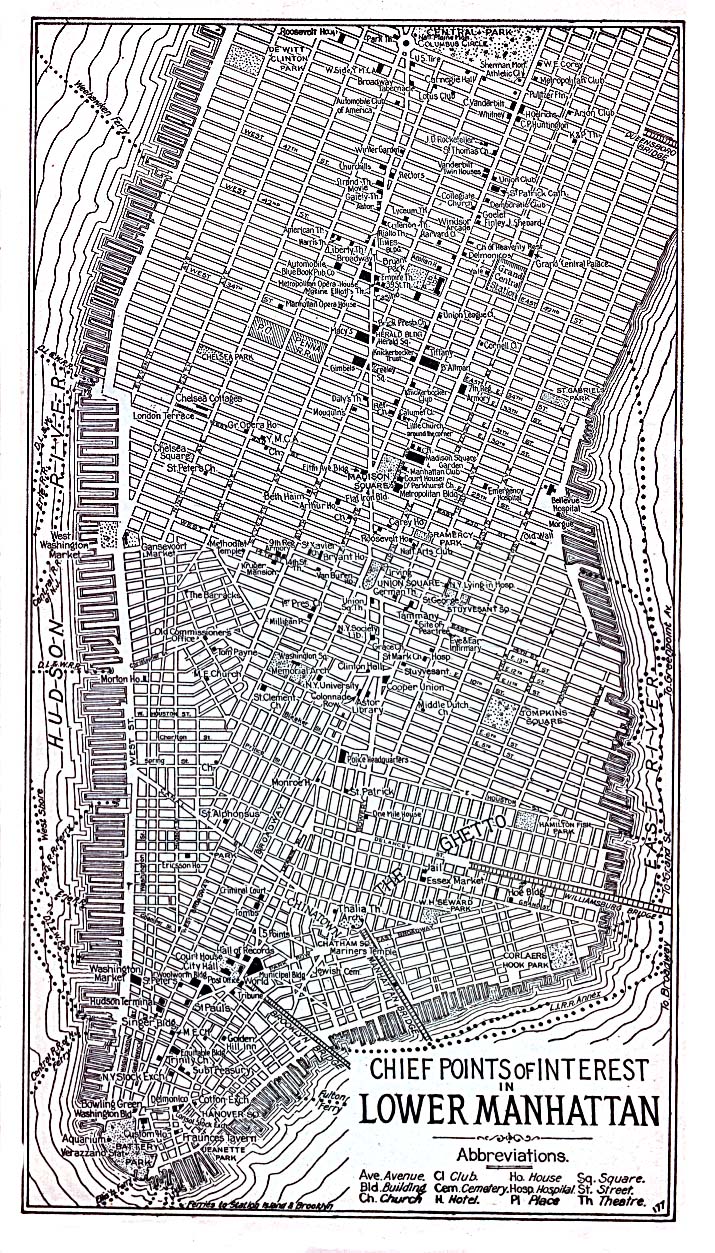
http://www.onewal.com/ny1930.gif |
| Subject:
Re: New York Map and/or aerial photo circa 1931
From: chester54-ga on 15 Feb 2005 16:34 PST |
An Insurance company printed a book in about 1950 which covered the history of fire departments from about 1750 to 1950. Many maps were included in the book which show the streets, buildings and points of interest. Several "overlay" old and current streets. The title of the book is "As You Pass By" if I remember it correctly. The book also has a list of "old" street names with the location listed in relation to current maps of 1950. Good luck. |
| Subject:
Re: New York Map and/or aerial photo circa 1931
From: chester54-ga on 15 Feb 2005 16:35 PST |
An Insurance company printed a book in about 1950 which covered the history of fire departments in New York City from about 1750 to 1950. Many maps were included in the book which show the streets, buildings and points of interest. Several "overlay" old and current streets. The title of the book is "As You Pass By" if I remember it correctly. The book also has a list of "old" street names with the location listed in relation to current maps of 1950. Good luck. |
| Subject:
Re: New York Map and/or aerial photo circa 1931
From: sijan-ga on 19 Feb 2005 14:35 PST |
Here is a map of NYC from 1934 - you can zoom in to look at specific areas: http://www.brorson.com/maps/NYC/NYC1934/ This map in particular seems to cover the area you're interested in: http://www.brorson.com/maps/NYC/NYC1934/LowerManhLevel2_1200_3164_4180.html Let me know if this works. I'm not sure how I can collect on this since I'm not an official answerer... |
| Subject:
Re: New York Map and/or aerial photo circa 1931
From: sijan-ga on 19 Feb 2005 14:37 PST |
that 1934 map linked above is a Rand McNally map |
If you feel that you have found inappropriate content, please let us know by emailing us at answers-support@google.com with the question ID listed above. Thank you. |
| Search Google Answers for |
| Google Home - Answers FAQ - Terms of Service - Privacy Policy |