Hello Jdlquestion,
Below you will find free hurricane statistics for the United States.
THE DEADLIEST, COSTLIEST, AND MOST INTENSE UNITED STATES TROPICAL
CYCLONES FROM 1851 TO 2005
Eric S. Blake, Jerry D. Jarrell (retired), and Edward N. Rappaport
NOAA/NWS/Tropical Prediction Center/National Hurricane Center
Miami, Florida
Christopher W. Landsea
NOAA/AOML/Hurricane Research Division
Updated July 2006 (Appendix A)
http://www.nhc.noaa.gov/Deadliest_Costliest.shtml
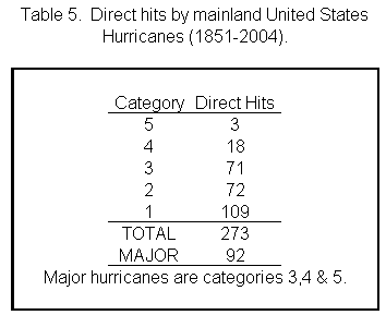
Table 5 summarizes the direct hits on the U. S. mainland since 1851.
?The data indicate that an average of 3 major hurricanes every 5 years
made landfall somewhere along the U.S. Gulf or Atlantic coast. (All
categories combined average about 5 hurricanes every 3 years.) Note
that not all areas of the U.S. were settled before 1900 and there
could be substantial gaps in landfall data coverage, especially in
South Florida.?
Table 5
http://www.nhc.noaa.gov/gifs/table5.gif
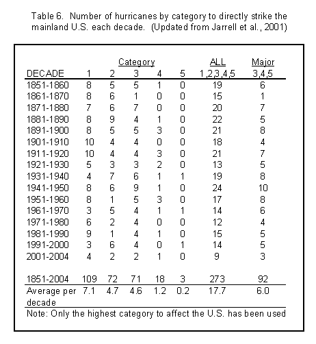
Table 6 lists hurricanes by decades since 1851.
??shows that during the forty year period 1961 2000 both the number
and intensity of landfalling U.S. hurricanes decreased sharply! Based
on 1901 1960 statistics, the expected number of hurricanes and major
hurricanes during the period 1961 2000 was 75 and 28, respectively.
But, in fact, only 55 (or 74%) of the expected number of hurricanes
struck the U.S. with only 20 major hurricanes or 71% of that expected
number. Even the very active late 1990s showed below average landfall
frequencies. It could be noted that of the most recent four decades,
only the 70's and 80's were significantly below normal in terms of
overall tropical cyclone activity.
During the past 35 years, the United States has experienced three
Category 4 or stronger hurricanes: Charley in 2004, Andrew of 1992 and
Hugo of 1989. However, on the average, a category 4 or stronger
hurricane strikes the United States once every 6 or 7 years. This
suggests we have seen fewer exceptionally strong hurricanes than an
expected 35 year average of about 5 or 6. Fewer hurricanes do not
necessarily mean a lesser threat of disaster, however. Records for the
most intense U.S. hurricane in 1935, and the costliest, Andrew in
1992, occurred in years which had much below-average hurricane
activity.?
Table 6
http://www.nhc.noaa.gov/gifs/table6.gif
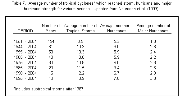
Table 7 gives the average number of tropical cyclones which reached
tropical storm, hurricane and major hurricane strength during selected
time periods.
Table 7
http://www.nhc.noaa.gov/gifs/table7.gif
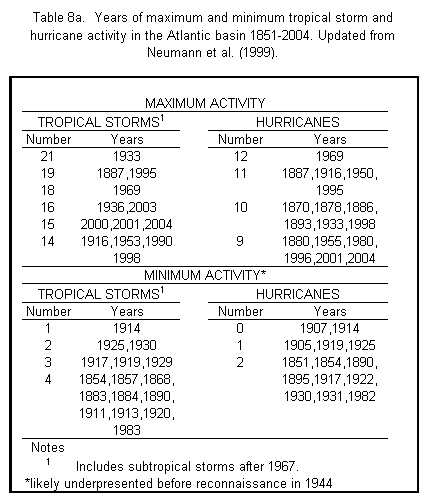
Table 8a shows the years of maximum and minimum tropical storm and
hurricane activity for the Atlantic hurricane basin.
Table 8a
http://www.nhc.noaa.gov/gifs/table8a.gif
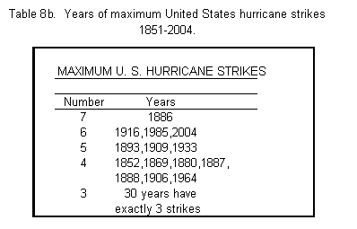
Table 8b lists the years of maximum United States hurricane landfalls.
?The only times that the U.S. mainland has gone as long as two years
without a hurricanes are 1862-64, 1930-31, 1981-82 and 2000-01. Note
there is considerable uncertainty before 1900 because significant
areas of the Gulf and Southeast Atlantic coasts were unpopulated and
uninstrumented. The largest number of hurricanes to strike in one year
was seven (1886), with six occurring in 1916, 1985, and 2004, plus
five in 1893, 1909 and 1933. Three or four hurricanes have struck the
U.S. in one year a total of 37 times. Eleven U.S. hurricanes were
recorded in the two-year period 1886-87 with 15 recorded from
1886-1888.?
Table 8b
http://www.nhc.noaa.gov/gifs/table8b.gif
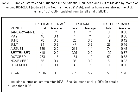
Table 9, shows the total and average number of tropical storms, and
those which became hurricanes, by month, for the period 1851 2004. It
also shows the monthly total and average number of hurricanes to
strike the U. S. since 1851.
Table 9
http://www.nhc.noaa.gov/gifs/table9.gif
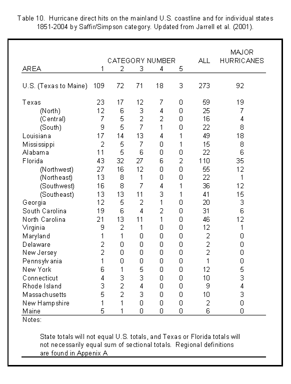
Table 10 shows the number of hurricanes affecting the United States
and individual states, i.e., direct hits. The table shows that, on the
average, close to seven hurricanes every four years (~1.75 per year)
strike the United States, while about three major hurricanes cross the
U.S. coast every five years (0.60 per year). Other noteworthy facts,
updated from Jarrell et al. (2001), are: 1.) Forty percent of all U.S.
hurricanes hit Florida; 2.) Eighty-three percent of category 4 or
higher hurricanes strikes have hit either Florida or Texas; 3.)
Pennsylvania?s only hurricane strike between 1851-2004 was 1878.
Table 10http://www.nhc.noaa.gov/gifs/table10.gif
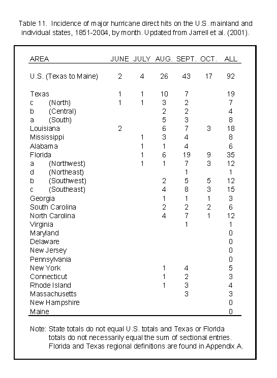
Table 11 shows the incidence of major hurricanes by months for the
U.S. mainland and individual states. ?September has as many major
hurricane landfalls as October and August combined. Texas and
Louisiana are the prime targets for pre-August major hurricanes. The
threat of major hurricanes increases from west to east during August
with major hurricanes favoring the U.S. East Coast by late September.
Most major October hurricanes occur in southern Florida.?
Table 11
http://www.nhc.noaa.gov/gifs/table11.gif
Are there hurricane cycles?
?Figures 1 through 16 show the landfalling portion of the tracks of
major hurricanes that have struck the United States between 1851-2004.
The reader might note the tendency for the major hurricane landfalls
to cluster in certain areas during certain decades. Another
interesting point is the tendency for this clustering to occur in the
latter half of individual decades in one area and in the first half of
individual decades in another area. During the very active period of
the thirties this clustering is not apparent.
A comparison of twenty year periods beginning in 1851 indicates that
the major hurricanes tended to be in Gulf Coast states before 1891,
then favored Florida and the W. Gulf until 1911, shifting to the
eastern Gulf Coast states and Florida during the next twenty years,
then to Florida and the Atlantic Coast states during the 1940s-1950s,
and back to the western Gulf Coast states in the following twenty-year
period.?
http://www.nhc.noaa.gov/Deadliest_Costliest.shtml#Figures
Source: National Hurricane Center
------------------
Here you will find yearly Atlantic hurricane data by year.
http://www.aoml.noaa.gov/hrd/hurdat/easyhurdat_5103.html
Taken from the National Weather Service:
http://www.prh.noaa.gov/cphc/pages/FAQ/Historical_Information.php
-------------------
The Tropical Meteorology Project
The Tropical Meteorology Project is headed by Colorado State
University's Dr. William Gray. Professor Gray has worked in the
observational and theoretical aspects of tropical meteorological
research for more than 40 years. Most of this effort has gone to the
investigation of meso-scale tropical weather phenomena..Dr. Gray's
hurricane forecast has gained international attention, and won him the
Neil Frank Award of the National Hurricane Conference in 1995.
http://hurricane.atmos.colostate.edu/
His Atlantic basin hurricane forecasts are published here
Archived forecasts are also available.
http://hurricane.atmos.colostate.edu/Forecasts/
Tropical Meteorology Project Forecast Verifications
Verification of all of CSU's hurricane predictions from early
December, early April, early June and early August in MS Excel format.
By year
http://hurricane.atmos.colostate.edu/Includes/Documents/Publications/forecast_verifications.xls
Tropical Meteorology Project Presentations Available in Microsoft
Powerpoint Format here:
http://hurricane.atmos.colostate.edu/Includes/Documents/Presentations.html
-------------------
SUMMARY OF 2005 ATLANTIC TROPICAL CYCLONE ACTIVITY AND VERIFICATION OF
AUTHOR?S SEASONAL AND MONTHLY FORECASTS
http://hurricane.atmos.colostate.edu/forecasts/2005/nov2005/
Excerpts:
The 2005 hurricane season was the most active and destructive season
on record, and therefore had many unique characteristics.
Seasonal Characteristics/Records
? 23 named storms formed during the 2005 season. This is the most
named storms in a single season, breaking the old record of 21 named
storms set in 1933. However, there was no satellite coverage during
1933, and therefore it is quite possible that there may have been one
or more storms that were missed during the 1933 season.?
? 13 hurricanes formed during the 2005 season. This is the most
hurricanes in a single season, breaking the old record of 12
hurricanes set in 1969.?
?7 intense or major (Category 3-4-5) hurricanes formed during the 2005
season. This ties the single-season record for intense hurricanes set
in 1950.?
?103.25 named storm days were recorded during the 2005 season. This
is the second most named storm days in a single season, trailing only
the 1995 season (120.5 named storm days).?
?16.75 intense hurricane days were recorded during the 2005 season.
This ties 2005 with the 2003 season for the third most intense
hurricane days observed since 1950.?
?The season accumulated 249 NTC units. This breaks the record of 230
NTC units which was set in 1950.?
?Three Category 5 hurricanes formed during the 2005 season (Katrina,
Rita, and Wilma). This is the most Category 5 hurricanes recorded in
a single season, breaking the old record of two Category 5 hurricanes
set in 1960 and 1961. Also, when the 2004-2005 seasons are combined,
four Category 5 hurricanes have formed (Ivan, Katrina, Rita and
Wilma). This ties the consecutive-year record set in 1960-1961 when
four Category 5 hurricanes also formed.?
?Seven named storms made United States landfall during 2005 (Arlene,
Cindy, Dennis, Katrina, Rita, Tammy and Wilma). This puts the 2005
season in a tie for second place for landfalling storms behind the
1916 and 2004 seasons where eight named storms made landfall.?
?The 2005 season was the most damaging in history for United States
landfalling storms, largely due to Hurricane Katrina. Insured damage
estimates for the 2005 season are nearly $70 billion dollars, which
shatters the old records set in 1992 and 2004, which when adjusted for
inflation, were each approximately $25 billion dollars in insured
damage.?
?The 2004 and 2005 hurricane seasons have been some of the most active
on record, but when compared with the very active recent seasons of
1995-1996, 1998-1999 and 2003, the activity of the past two years has
not been that extraordinary. Table 12 compares the average activity
of the 2004-2005 seasons with the average activity of the 1995-1996,
1998-1999 and 2003 seasons.?
Table 12:
Parameter 2004-2005 1995-1996; 1998-1999; 2003
Named Storms 18.5 14.8
Named Storm Days 96.8 89.0
Hurricanes 11.0 9.0
Hurricane Days 45.4 45.5
Intense Hurricanes 6.5 4.4
Intense Hurricane Days 19.5 13.1
Net Tropical Cyclone Activity 239 188
Table 12 Verification of Previous Forecasts
http://hurricane.atmos.colostate.edu/forecasts/2005/nov2005/
-------------------
Search terms:
Hurricane data statistics United States
I hope the information provided is helpful!
Best regards,
Bobbie7 |
Clarification of Answer by
bobbie7-ga
on
10 Nov 2006 07:28 PST
Hello Jdlquestion,
Additional information:
Major Hurricanes Predicted to Increase in Years Ahead
for National Geographic News
July 20, 2001
The North Atlantic, Caribbean, and Gulf of Mexico regions can expect
increased hurricane activity in the next 10 to 40 years.?
According to Chris Landsea, a meteorological researcher with the U.S.
National Atmospheric and Oceanic Administration (NOAA) Hurricane
Research Division : "We've seen a big increase in the number of
hurricanes since 1995, and in the next 30 years we're going to see a
lot more," and "It's part of a natural cycle.?
?By using a combination of satellite imagery, computer modeling, and
high-tech monitoring of numerous factors?from sea-surface temperatures
to atmospheric conditions?the team of scientists has identified a
multi-decade pattern of likely hurricane activity. These long-term
patterns can be classified as quiet, near normal, or active.?
?During the 20th century, a period of high hurricane activity occurred
from the 1920s through the 1960s, followed by reduced activity from
1971 to 1994.?
?The researchers predict that we are now on the cusp of a 10- to
40-year shift toward increased frequency of hurricanes.?
Landea goes on to say that the long-term average is about ten storms a
year, with about one and a half developing into "major" hurricanes,
and that number is likely to increase to three per year in the next
several decades
National Geographic News
http://news.nationalgeographic.com/news/2001/07/0719_hurricanes.html
Active period for major hurricanes that may last at least another 10 or 20 years
?Forecasters at the National Oceanic and Atmospheric Administration
say they don't expect a repeat of last year, which saw a record 28
named storms and 15 hurricanes. But they say warm Atlantic
temperatures and favorable wind conditions could produce up to 10
hurricanes and up to six major hurricanes -- Category 3 or above --
with winds topping 111 mph.?
?The Atlantic Basin has been in an active phase since 1995, with nine
of the last 11 hurricane seasons above normal, according to the NOAA .
National Hurricane Center director Max Mayfield said the trend could
continue for years.
"We're in this very active period for major hurricanes that may last
at least another 10 or 20 years," he said. "That's not good news, and
the message is very clear that we have to be prepared."
Global Warming
?Florida State University professor James Brian Elsner said he also
believes global warming is starting to influence Atlantic hurricanes.
"I'm not sure that hurricanes and typhoons worldwide are seeing an
effect, but I think in the Atlantic the strong correlation between the
global air temperature and the sea surface temperatures in the
Atlantic -- which is really the fuel for hurricanes -- is very large,"
he said.?
CNN
http://edition.cnn.com/2006/WEATHER/06/06/hurricane.science/
Meteorologists say the cycle of active hurricane seasons began in 1995
and will continue for many years.
National Geographic
http://news.nationalgeographic.com/news/2006/02/0227_060227_hurricane_coast.html
?The cycles take 25 to 40 years to run their courses. The present
cycle of increased hurricanes started in 1995 and is expected to
continue for at least another decade, perhaps longer.?
National Geographic
http://news.nationalgeographic.com/news/2005/08/0808_050808_hurricane_2.html
?..around the time Hurricane Katrina stormed ashore in Mississippi,
climate scientists were engaged in an urgent debate. According to one
group, the increasing intensity of Atlantic storms comes from a
natural climate cycle that causes sea surface temperatures to rise and
fall every 20 to 40 years. According to another group, it comes from
human emissions of carbon dioxide and other greenhouse gases. (So far,
no one has linked the number of hurricanes to global warming.) In the
first scenario, the fever in the Atlantic might not break for another
decade or more; in the second, it might last for the rest of this
century and beyond.?
Smithsonian Magazine
http://www.smithsonianmagazine.com/issues/2006/september/storm.php
From Climate Science Watch:
?Two new studies by leading climate scientists quantify a connection
between human-induced global warming and recent enhanced North
Atlantic hurricane activity. The studies conclude that natural
variability plays only a minor role. The research was supported by
the National Science Foundation, a participating agency in the federal
Climate Change Science Program.?
Check out the abstracts and introductions to these two studies here:
http://www.climatesciencewatch.org/index.php/csw/details/new-hurricane-studies/
The Recent Increase in Atlantic Hurricane Activity: Causes and Implications
?The years 1995 to 2000 experienced the highest level of North
Atlantic hurricane activity in the reliable record. Compared with the
generally low activity of the previous 24 years (1971 to 1994), the
past 6 years have seen a doubling of overall activity for the whole
basin, a 2.5-fold increase in major hurricanes, and a �vefold increase
in hurricanes affecting the Caribbean. The greater activity results
from simultaneous increases in North Atlantic sea-surface temperatures
and decreases in vertical wind shear. Because these changes exhibit a
multidecadal time scale, the present high level of hurricane activity
is likely to persist for an additional ;10 to 40 years.?
Read the complete article here:
http://www.sciencemag.org/cgi/content/full/293/5529/474
Hurricane Cycles
?Meteorologists have noted that hurricane seasons run in alternating
cycles of active and less active seasons. These cycles last from 25 to
40 years.
Active seasons are thought to be triggered by the concentration of
salt in ocean water. When the salt content is higher, the water is
warmer and more hurricanes form.
Meteorologists believe that a cycle of active seasons started in 1995
and could continue for another 15 to 30 years.?
http://news.nationalgeographic.com/news/2006/03/0328_060328_hurricane_2.html
New research by insurance companies shows even greater peril from hurricanes
Risk Management Solutions ? is predicting that hurricanes will occur
with much greater frequency and intensity over the next five years,
and is telling insurers they need to increase their annual loss
estimates by 25 percent to 30 percent in New England and the
mid-Atlantic states, and 40 percent across the Gulf Coast, Florida,
and Southeast.?
?Most hurricane models use historical data to forecast hurricane
frequency and intensity, but Risk Management says that approach is no
longer sufficient. ''There's enough data and science to support the
view that hurricane activity will be different from what it has been
on a historical basis," said Paul VanderMarck, executive vice
president at Risk Management. Kerry A. Emanuel, a professor of
meteorology at the Massachusetts Institute of Technology who served on
a four-member panel of specialists consulted by Risk Management, said
there are two schools of thought about Atlantic hurricane activity.
One school holds that hurricane activity rises and falls in
multidecade cycles, with the Atlantic currently in an active cycle
that is expected to last another 10 to 20 years. The other school of
thought holds that climate warming is changing hurricane dynamics, and
the ups and downs of the past are giving way to a more stable trend
line that will increase long-term risks for insurers.?
?AccuWeather.com, a Pennsylvania-based commercial weather service,
earlier this month said conditions are ripe for a devastating
hurricane of the magnitude that struck New England in 1938, leaving
600 dead.?
BOSTON GLOBE April 02, 2006
http://www.cleanpowernow.org/modules.php?op=modload&name=News&file=article&sid=297&mode=thread&order=0&thold=0
Risk Management Solutions
U.S. and Caribbean Hurricane Activity Rates
The New RMS Medium- Term Perspective and Implications for Industry Loss
March 2006
?Atlantic hurricane activity has remained persistently high since 1995
(except for El Ni�o years). In 2004 and 2005, the high activity in the
basin translated into U.S. landfall and the highest loss years ever
experienced by the insurance industry. With strong evidence that
higher than average activity rates are likely to persist for at least
a decade, it is no longer appropriate to employ a longterm historical
baseline for characterizing medium-term activity rates in hurricane
catastrophe (Cat) models. Acknowledging that the long-term historical
baseline is no longer the best measure of current activity also means
it is necessary to be explicit about the intended time horizon of Cat
model activity rate projections. In developing the new medium-term
five-year view of risk, RMS has taken counsel from representatives
across the insurance industry in determining that future model output
will be for a ?medium-term? five-year risk horizon. In October 2005,
RMS called an expert meeting of four leading hurricane climatologists
to arrive at a consensus forecast for medium-term hurricane activity
in the Atlantic basin, at U.S. landfall, and in the Caribbean. For the
U.S., the medium-term
perspective represents about a 20% increase in Saffir-Simpson category
1-2 hurricanes and over a 30% increase in category 3-5 hurricane
landfall rates relative to a 1900-2005 historical baseline.?
?This view of hurricane activity rates has been implemented within the
U.S., Caribbean, and Offshore Platform models in RiskLink and
RiskBrowser, based on RMS hurricane type, geographical region and
Saffir-Simpson category. The impact of these changes in hurricane
activity rates will increase average annual losses (AALs) by
approximately 40% on average across the Gulf Coast, Florida, and the
Southeast, and by 25-30% in the Mid-Atlantic and Northeast coastal
regions. When compared with a pre-2004 historical baseline, as has
been previously employed for quantifying insurance risk, the increases
in modeled annualized losses are closer to 50% in the Gulf, Florida,
and the Southeast.?
Download the full text of this whitepaper here for additional details
http://www.rms.com/Publications/60HUActivityRates_whitepaper.pdf
|
 ,
0 Comments
)
,
0 Comments
)