lacigol-ga,
The images I will refer you to are not from Discover Magazine, but do
come from the NOAA National Satellite and Information Service... which
is probably where the magazine got the image/s from in the first
place.
Still images and spinning globe images (with color relief) can be
found in the Marine Geology and Geophysics section of the National
Geophysical Data Center's website (Ref. 1, see the bottom of the
answer for references). Try the "Relief Globe Slide Set - JavaScript
Online Preview" for large false-color images.
Depending on what you will be using these images for, you may want to
read the usage statement on the page, which I will quote here:
"The Images offered here are .GIF .JPG or .MPEG images produced in the
National Geophysical Data Center's Marine Geology & Geophysics
Division, or from MGG data in cooperation with scientists from other
organizations. These images are in the public domain, with the
exception of images in outside publications to which we provide links.
If you use them, please credit NOAA/NGDC for the image and the
underlying data sources/funding institutions of data from which the
images were derived."
NASA also has a website with some interesting photos (Ref 3; more
specifically, I think you may be interested in the second image set).
If images other than a round globe can fulfill your needs, extremely
detailed "flat" images can be seen here (Ref 4):
http://www.ngdc.noaa.gov/mgg/image/2minrelief.html
and here (Ref 5.):
http://www.ucmp.berkeley.edu/tectonics/quakecenters.html
Please let me know if these images do not fulfill your needs.
Best Regards,
krobert-ga
References:
1) NGDC/WDC MGG, Boulder - Marine Geology & Geophysics Images
http://www.ngdc.noaa.gov/mgg/image/images.html#relief
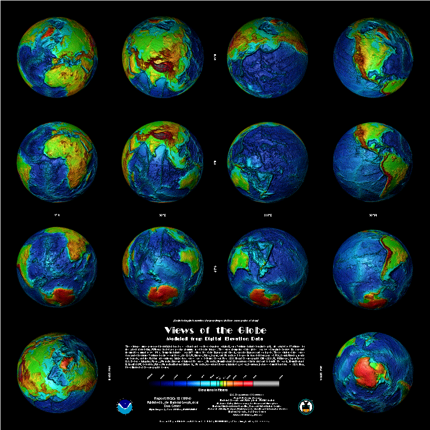
2) Poster (gif image, available for ordering though): Views of the
Globe
http://www.ngdc.noaa.gov/mgg/image/mgg_10.gif
3) NASA - Earth Science Image Gallery
http://www.earth.nasa.gov/Introduction/gallery.html
4) NGDC/WDC MGG, Boulder - 2 Minute Bathmetry/Topography Image
Selector
http://www.ngdc.noaa.gov/mgg/image/2minrelief.html
5) Map of Earthquake Epicenters
http://www.ucmp.berkeley.edu/tectonics/quakecenters.html |
Request for Answer Clarification by
lacigol-ga
on
05 Nov 2002 12:32 PST
I'm sorry!  But the relief maps aren't it.  If you could picture earth
without water as a rock in the palm of your hand....that is what the
pictures looks like.  I'm very sure the image was in Discover within
the last 1-2 years.  I'll keep digging through the sites you have
mentioned and will let you know if they link to the specific image I
am referring to.
|
Request for Answer Clarification by
lacigol-ga
on
05 Nov 2002 12:34 PST
if it helps...the picture (image scan) had a black background and the
earth as a rock was colored golden brown....
|
Clarification of Answer by
krobert-ga
on
05 Nov 2002 12:53 PST
I know which one your talking about and I'll keep looking.

If the image can't be found, I suggest that you could take the photos
from NASA's website, reduce them to grayscale in an image editor and
them adjust the hue to make them a golden brown. I don't think that
would satisfy you completely based on what you have already stated,
but it may put you better off that you we're.

krobert-ga
|
Clarification of Answer by
krobert-ga
on
05 Nov 2002 16:25 PST
lacigol-ga,

I've done a more extensive search and haven't been able to find the
particular image that you are requesting. Perhaps tutuzdad-ga may have
a more specific answer to post in the comments.

I hope that the relief maps I linked were at least of some interest if
not the final solution for you.

krobert-ga
|
Request for Answer Clarification by
lacigol-ga
on
05 Nov 2002 19:06 PST
Still not it.  I spent the last hour at the library going through some
discover magazines.  I didn't get to stay there as long a I expected.
Regardless, none of these are it!  It is a WILD shaped rock and it
isn't a relief map (there are no marked boundries on the map; by color
or lines)
|
Clarification of Answer by
krobert-ga
on
05 Nov 2002 20:31 PST
lacigol-ga

Could you describe "WILD" a bit better? The relief maps I pointed you
to are the earth as it is without water... it's just that they are
topographically colored, not the golden brown you specify.

Perhaps it was a distorted relief map of the earth?

Do you think it may be completely computer generated... in which case
we should stop looking for "earth" in our searches and look for
"planet", "planetoid" or "moon" instead.  On that note, there are some
very interesting -real- pictures of mercury/venus/mars/moons(jovian)
that are pretty wild looking rocks.

Were there actually identifiable continents in this picture or was
there some other pattern... such as the odd surface features of Europa
or Ganymede.

krobert-ga


FYI - Base on your comments, I think that this is still off the mark,
but, if you didn't see it below in the comments, this link was
provided by tutuzdad-ga.  And tutuzdad is right, the mpeg is cool!

NASA Goddard Space Flight Center - Scientific Visualization Studio
“HoloGlobe: Topography and Bathymetry on a Globe”
http://svs.gsfc.nasa.gov/vis/a000000/a001300/a001305/
|
Clarification of Answer by
krobert-ga
on
05 Nov 2002 21:04 PST
One more little gem that may be a little off of what you really want...

Polygon Worlds Space Visualization Software: Earth3D Viewer
http://planet3d.demonews.com/PWEarth3DViewer.htm

You can turn off the color and set it so that you can view the ocean floor.

The rest of the website is worth checking out as well.

krobert-ga
|
Request for Answer Clarification by
lacigol-ga
on
05 Nov 2002 21:11 PST
http://gemini.utsi.edu/earth/  i've hand drawn two images that SHOW
what i mean by wild.  one is the earth with no water (ROUGH DRAWING)
and the other shows the water outline.  What i'm looking for isn't a
PICTURE and instead data put together from some type of scan to make a
computer IMAGE i suppose.  You have gotten the $20 dollars already
right?  I think you've done enough work and I'll tip you if you come
up with the image i'm looking for.  i appreciate the movie, but the
scale of the relief in the movie makes earth look "rounder" than it
actually is.  Let me know if you have any questions.
|
Clarification of Answer by
krobert-ga
on
06 Nov 2002 07:55 PST
lacigol-ga,

Sorry about not finding the exact image for you.  If I run across it,
I'll be sure to post the source for you.

Best Regards,

krobert-ga
|